Heading offshore from any of Texas’ notable blue-water destinations is a trip, and on any given day anglers have the opportunity to catch everything from ling, snapper and grouper to mackerel, sharks and amberjack.
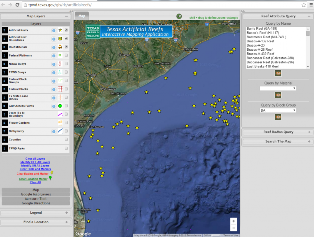
However, simply knowing what species are swimming out there is only half the battle. You’ve got to find them, too, but thanks to the state’s artificial reef program, there are multiple locations to target deep-water structure. And the best part is, there are maps and GPS coordinates that will help you find your way.
The Texas Artificial Reef program, one of the largest efforts in the country, began in 1990 and features nearly 70 reef sites, mostly situated in federal waters that begin 9 miles into the Gulf of Mexico. Those sites are divided into three categories: decommissioned drilling rigs (Rigs to Reefs Program), highway bridge materials and other types of concrete and heavy-gauge steel (Nearshore Reefing Program), and large marine vessels (Ships to Reefs Program).
Any old salt can tell you exactly why we’ve got these fish-attracting initiatives: the terrain of the Gulf is mostly barren and these structures help provide sustenance from the bottom of the food chain all the way to the top for hundreds of species of fish and invertebrates.
Multiple Texas-based projects, including nearshore reefs off Freeport and Matagorda, have benefited from millions of dollars in funding to help compensate for lost human use of natural resources resulting from the Deepwater Horizon oil spill in 2010 in the Gulf. Those projects and others in prime fishing habitat have been aided in restoration led by state and federal Natural Resource Damage Assessment trustees. In addition, a 155-foot former freighter was scuttled in 2014 about 9 miles offshore from Mustang Island and Port Aransas. The Kinta S was the largest ship to be reefed since the 473-foot Texas Clipper was sunk 17 miles off South Padre Island in 2006. The effort helped to enhance an existing site known as the Corpus Christi Nearshore Reef, which was composed of 470 concrete pyramids and several thousand tons of concrete culverts.
In addition to improving fishing opportunities, the reef is one of eight such sites within 9 nautical miles of shore that offers diving opportunities.
The real boon to the overall artificial reefing initiative has been Rigs to Reefs, with multiple rigs donated in recent years by cooperating oil and gas companies. In addition to the physical infrastructure, these companies also have donated to the Texas Artificial Reef Fund half of their realized savings from not having to take the rigs to shore. Those dedicated funds are used to finance research, administration, maintenance, liability coverage and construction of new reefs, providing a win for all parties involved.
As a result, our state’s artificial reef program is self-sufficient, relying on no funds from public sources or agency revenue.
The artificial reefing program also has gained valuable scientific partners with researchers closely monitoring fish census and other data measures. Researchers from the Harte Research Institute for Gulf of Mexico Studies used a variety of testing methods including diver-based surveys and ROV-based surveys to further describe just how important these structures are to one of the world’s most distinct and valuable ecosystems.


